HORIZON INTERNATIONAL SOLUTIONS SITE
Working to Find and advance solutions to environment, health, poverty, and development problems
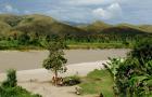
A new modeling approach using satellite data will likely to enhance our ability to develop cholera risk maps in several regions of the globe. The model (GCRM) is based on monthly air temperature, precipitation, availability of WASH (water, sanitation and hygiene) infrastructure, population density and severity of natural disaster.
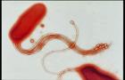
The world has seen seven global cholera outbreaks since 1817, and the current one seems to have come to stay. Rising temperatures and a stubbornly persistent, toxic bacteria strain appear to have given the disease the upper hand.